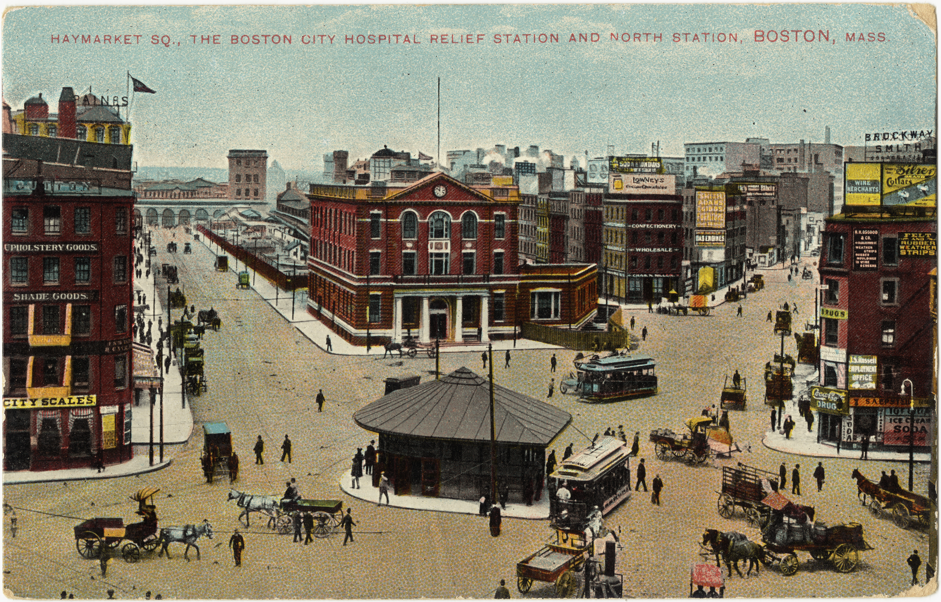
At turn of the 20th century Haymarket Square looked like this.
Now there is a massive row of highways that has been laid on top and the eastern (i honestly don't know which direction this is facing but i will find out when I visit) portion of the square is covered by a mass of pavement - Highway 1 and I-93 among others. Comparing the current map to this picture it seems that the square was originally located on one of the two eastern corners of what is today the Haymarket T Station.
Haymarket was opened as an open air market in 1830 according to this 2005 article. However, I did find a book in Rotch library that was written in 1970 and claims Haymarket has been open in some form or another for 300 years, leaving us around 1670 (Snyder, 1970). To be fair, the book is more of a book of poems, quotes, and pictures, and less of a historical reference. Given Boston was founded in late 1630, this is possible but there is quite a difference between those two starting dates. Until I learn more I will assume that a market of some form has long been present in the general vicinity of Boston.
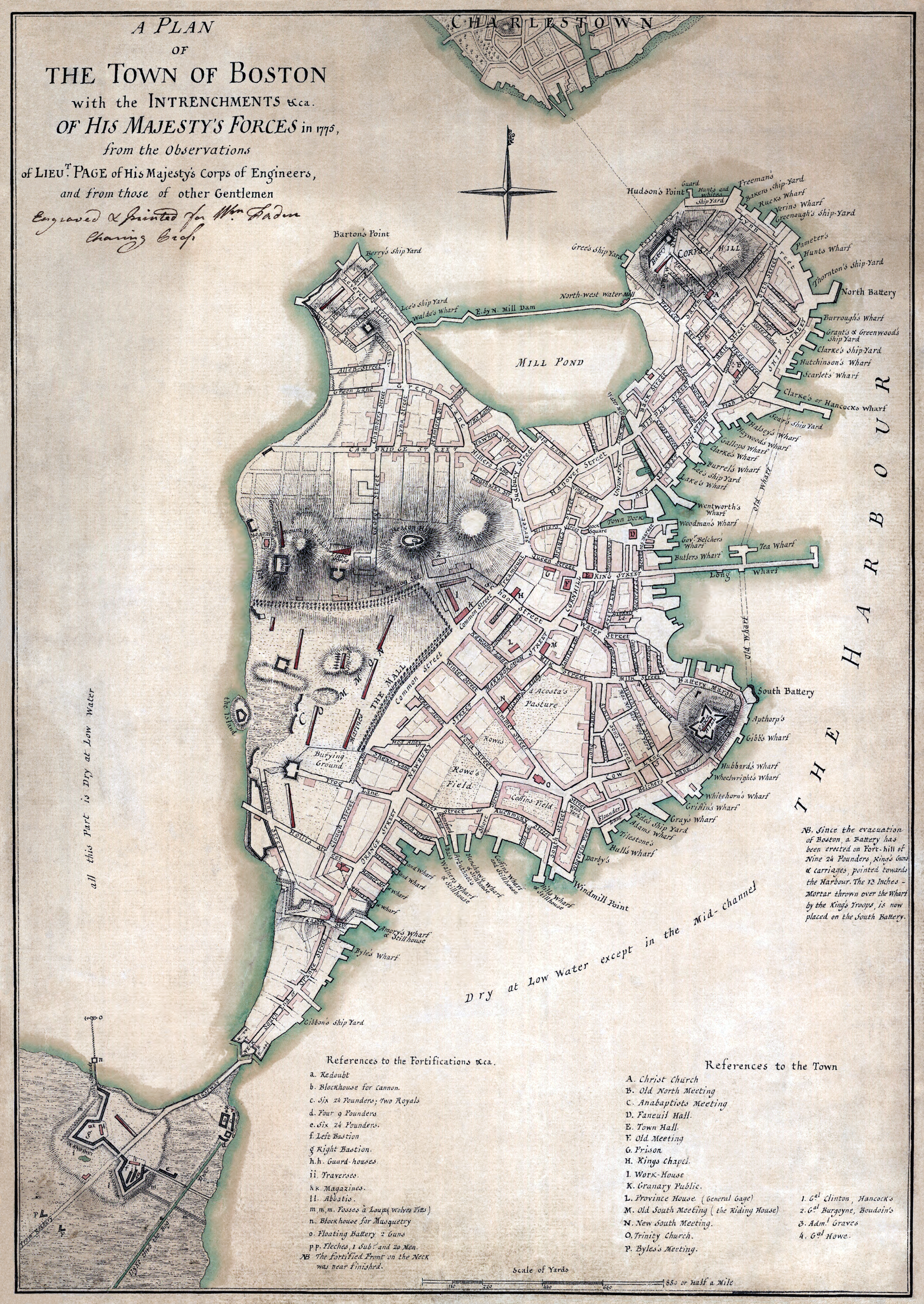
More on the topic of nature, I am very interested in trying to map out exactly where my site is located relative to old maps before the land was filled. I know it is near the southeastern tip of Mill Pond, and it is quite likely that part of my site is in the water, so I spent some time trying to orient myself on this 1775 map. One thing that seems quite clear - oh wait! check out this map! By using this map from 1871 (note that Mill Pond is filled in) and combining all three aforementioned maps (including google maps), I was able to answer most all of my questions for the location of my site. It turns out Haymarket Square was located just outside the southeastern corner of what is today Haymarket T Stop. Between 1775 and 1871 a small creek called Mill Creek (with a Water Mill that seems to have been set up to run off of tides with outflow controlled by the dammed Mill Pond.
The three streets that were present on all the maps are: Union Street, Hanover Street, and Cross Street. Since Hanover intersects with Cross and Union this was the best clue for finding the exact location of my site near my site this was helpful as a reference. Looking closely, and going back and forth between the maps, I can now tell precisely where my site is. To illustrate this I made a quick sketch of my site (in red) overlayed upon the 1775 map. Note that part of my site is indeed in Mill Pond. The blue X marks a close estimate of the location of Haymarket Square, and the two blue lines farther south mark the main two streets of Haymarket. As you can see, Blackstone Street was in fact Mill Creek at one time. There should be signs of this at my site. It is clear, that Blackstone was added when Mill Pond was filled in the 1800's. Possibly it was buried similar to the creek in Dudley Square? Note further that there is a small inlet of green on the map below that represents an inlet or creek branching off of Mill Creek. Along this location today we find a street called none other than Creek Street.

I would like to find this map but bigger so I will look for that in the archives. One final note to conclude: It seems that my dating question has in part been answered as well since the Mill Pond filling began in 1807 and finished in mid-1800's. Therefore Haymarket could have existed 300 years ago in some fashion, possibly even along the creek, but certainly not in any fashion very similar to today.
